


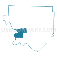
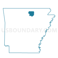
BOSWELL Voting District, Izard County, Arkansas
About
Outline

Summary
| Unique Area Identifier | 526720 |
| Name | BOSWELL Voting District |
| County | Izard County |
| State | Arkansas |
| Area (square miles) | 26.99 |
| Land Area (square miles) | 26.70 |
| Water Area (square miles) | 0.29 |
| % of Land Area | 98.91 |
| % of Water Area | 1.09 |
| Latitude of the Internal Point | 36.02480680 |
| Longtitude of the Internal Point | -92.03208500 |
Maps

Graphs
Select a template below for downloading or customizing gragh for BOSWELL Voting District, Izard County, Arkansas


Neighbors
Neighoring Voting District (by Name) Neighboring Voting District on the Map
- CLAIRBORNE Voting District, Izard County, AR
- KNOB CREEK Voting District, Izard County, AR
- LUNERBURG Voting District, Izard County, AR
- MELBOURNE RURAL Voting District, Izard County, AR
- Optimus Voting District, Stone County, AR
- TWIN CREEK SYLAMORE Voting District, Izard County, AR
Top 10 Neighboring County Subdivision (by Population) Neighboring County Subdivision on the Map
- Mill Creek township, Izard County, AR (2,173)
- White River township, Izard County, AR (258)
- Optimus township, Stone County, AR (201)
- Claiborne township, Izard County, AR (167)
- Lunenburg township, Izard County, AR (156)
- Athens township, Izard County, AR (141)
- Mount Olive township, Izard County, AR (75)
Top 10 Neighboring Unified School District (by Population) Neighboring Unified School District on the Map
- Mountain View School District, AR (12,192)
- Melbourne School District, AR (5,339)
- Calico Rock School District, AR (3,587)
Top 10 Neighboring State Legislative District Lower Chamber (by Population) Neighboring State Legislative District Lower Chamber on the Map
Top 10 Neighboring State Legislative District Upper Chamber (by Population) Neighboring State Legislative District Upper Chamber on the Map
Top 10 Neighboring 111th Congressional District (by Population) Neighboring 111th Congressional District on the Map
Top 10 Neighboring Census Tract (by Population) Neighboring Census Tract on the Map
- Census Tract 9602, Izard County, AR (5,062)
- Census Tract 9501, Stone County, AR (4,003)
- Census Tract 9603, Izard County, AR (2,958)
- Census Tract 9604, Izard County, AR (2,549)